Data Gap Identification and Data Improvement Project

The Data Gap Identification and Data Improvement Project intends to enhance understanding of the hydrogeology and groundwater users in the Subbasin, supporting updates to the Groundwater Sustainability Plan (GSP) and the successful management of the Subbasin.
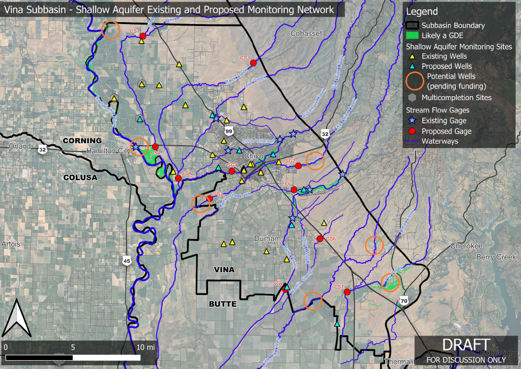
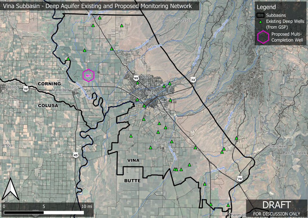
This project addresses gaps in understanding groundwater conditions related to domestic wells, interconnected surface waters, and groundwater-dependent ecosystems (GDEs). Key activities include the installation of multi-completion monitoring wells, shallow monitoring wells, and stream gages, as well as equipping domestic wells with monitoring equipment. These efforts aim to provide critical new data that will improve understanding over time.
The project also involves preparing the five-year GSP Periodic Evaluation and addressing recommended corrective actions identified by the Department of Water Resources (DWR). Newly available data and information will guide potential amendments to the GSP. Public and stakeholder engagement will occur through meetings of the Stakeholder Advisory Committee (SHAC) and GSA board, public workshops, and regular email updates to interested parties, building on the engagement strategies used during the development of the GSP.
To implement the project, the team will require access to land for identifying and installing new monitoring sites for wells and stream gages. Monitoring equipment will be deployed in new and existing wells to expand understanding of basin conditions and address data gaps identified in the GSP. Domestic well owners will have the opportunity to participate voluntarily in a community monitoring program, helping to expand the monitoring network. Targeted outreach will be conducted to landowners near proposed monitoring sites to encourage collaboration and participation.
Key Project Tasks:
- Expand and improve the groundwater monitoring network by drilling new multi-completion wells, shallow wells, and installing stream gauges.
- Expand Understanding of Basin Conditions: The installation of monitoring sites and equipment aims to address data gaps in the Vina subbasin, enhancing the understanding of hydrogeology and hydrology. This will support updates to the GSP and ensure effective management of the subbasin.
- Domestic Well Monitoring and Community Program: A key outcome is the creation of a monitoring program for domestic wells, equipping volunteer wells with monitoring devices to track water levels and enhancing the data management system for well data.
- Refine representative monitoring sites within the GSP as needed to better characterize and track conditions in both the upper and lower aquifer zones.
- Review and amend the GSP to address feedback from the DWR determination letter, incorporate newly available information, and integrate input from the community.
- Develop a methodology for sustainable management criteria specifically focused on interconnected surface water to ensure compliance with SGMA.
- Periodic GSP Evaluation: The project includes preparation for the five-year GSP evaluation, addressing the corrective actions recommended by the Department of Water Resources (DWR).
- Enhanced Stakeholder and Public Engagement: Regular meetings, workshops, and outreach activities will inform the public and stakeholders about the project's progress and encourage participation.
Consultant: Larry Walker Associates
Project Partner: Butte County Water and Resource Conservation
Total Project Budget: $1,465,000
Key Accomplishments
-
Fall 2024: Draft Proposed Monitoring Network Map
- Introduced to SHAC on October 23, 2024.
- Release for public comment: November 1 – November 30, 2024
- November 20, 2024, SHAC recommended the Board approve the proposed monitoring network
- December 11, 2024, the Vina GSA Board voted to approve the proposed monitoring network.
- Spring 2025: Collaborated with landowners to gauge interest and secure access agreements for new monitoring well sites.
- May 15, 2025: Filed a Notice of Exemption (NOE) with the State Clearinghouse and the Butte County Clerk.
-
May 2025: Invitation for Bids (IFBs) Posted:
The IFB for the installation of a multi-completion monitoring well was posted on Public Purchase on May 28, 2025. The IFB for the installation of shallow monitoring wells followed on May 30, 2025.
Schedule

Vina Subbasin - Upper Aquifer Existing and Proposed Monitoring Network