Inter-Basin Coordination Analysis and Modeling Project - Implemented by Butte County

The Inter-Basin Coordination Analysis and Modeling Project focuses on analyzing Groundwater Sustainability Plans (GSPs) from subbasins along the Northern Sacramento River and Feather River Corridors to support inter-basin coordination and establish a shared understanding of basin conditions at the boundaries. The project also involves integrated groundwater-surface water modeling, including refinements to the Butte Basin Groundwater Model.
The Northern Sacramento River Corridor includes the Red Bluff, Los Molinos, Corning, Vina, Colusa, and Butte subbasins. The Feather River Corridor includes the Butte, Wyandotte Creek, Sutter and North Yuba subbasins.
This Butte County led project is co-funded by grant awards received by the Vina and Wyandotte Creek Subbasins.
Consultant: Montgomery and Associates
Total Project Budget: $467,000
Key Project Tasks:
- Joint Analysis and Evaluation of GSPs - Evaluate and compare the contents of GSPs along each corridor region with a focus on establishing a common understanding of basin conditions at boundaries.
- Model Updates and Enhancements - Update input data and parameter values in the Butte Basin Groundwater Model (BBGM). Model time period will be extended through Water Year 2024.
2025 Summer Webinar Series Shares Results of Analysis
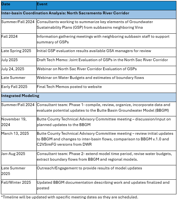
The following three-part webinar series will present results from the Joint Evaluation of Groundwater Sustainability Plans.
-
North Sacramento River Corridor Results
- Thursday, July 24, 2025 | 12:00–1:00 p.m.
- Overview of GSP evaluation results for the Vina, Butte, Colusa, Corning, Red Bluff, and Los Molinos Subbasins, including comparisons of key GSP elements such as monitoring networks and sustainability criteria.
- Recording of Webinar
- Presentation Slides
-
Feather River Corridor Results
- Thursday, August 7, 2025 | 12:00–1:00 p.m.
- Presentation of similar inter-basin analysis for the Feather River-adjacent subbasins: Butte, Wyandotte Creek, North Yuba and Sutter Subbasins.
- Recording of Webinar
- Presentation Slides
-
Inter-Basin Boundary Flows and Water Budget Results
- Thursday, August 28, 2025, 12:00 - 1:00 p.m
- A final webinar will focus on groundwater and stream-aquifer flow modeling results across subbasin boundaries.
- Recording of Webinar
- Presentation Slides
Project Timeline*

